Canyons represent the Earth’s most dramatic storytellers, revealing millions of years of geological history through their layered strata and carved abysses. These natural cathedrals, forged by the relentless forces of water, wind, and tectonic shifts, offer more than just scenic views; they provide a profound connection to the raw power of nature. From the high-altitude deserts of the American Southwest to the lush, mist-shrouded peaks of Tibet, canyons vary immensely in their ecology, spiritual significance, and physical challenge.
The Geological Majesty of Global Canyons
The formation of a canyon is a masterclass in erosion. Most of the world’s great canyons were birthed by the persistent flow of rivers cutting through uplifted plateaus. This process, known as downcutting, happens simultaneously with the weathering of the canyon walls, creating the wide, deep, and intricate structures we see today. The specific mineral composition of the rock—be it the iron-rich Navajo Sandstone of Utah or the ancient metamorphic rocks of the Himalayas—determines the vibrant colors and unique textures of each site.
The Role of Water and Time
Water is the primary architect. In arid regions, occasional but intense flash floods act like a sandpaper, scouring the rock and deepening the channels. In more temperate or tropical zones, consistent river flow combined with chemical weathering creates V-shaped valleys that eventually evolve into grand canyons. The sheer scale of these formations is difficult to comprehend; for instance, the Yarlung Zangbo Grand Canyon reaches depths that could swallow several Burj Khalifas stacked atop one another.
- Sedimentary Layering: Each layer represents a different epoch, containing fossils and minerals that tell the story of ancient oceans and deserts.
- Tectonic Activity: The lifting of the Earth’s crust provides the necessary elevation for rivers to gain the gravitational energy required for deep carving.
- Aeolian Erosion: Wind plays a secondary but vital role, especially in shaping delicate features like the hoodoos of Bryce Canyon.

Zion National Park: The Sacred Landscape of the Southwest
Zion Canyon is often described as a place of “Jerusalem-like desolation” mixed with a profound, sacred beauty. Located in southwestern Utah, Zion National Park is characterized by its massive cream, pink, and red sandstone cliffs. Unlike the Grand Canyon, where you look down from the rim, Zion invites you to walk the canyon floor and look up at the towering monoliths that seem to touch the heavens.
The Narrows and Angels Landing
The two most iconic experiences in Zion are the Narrows and Angels Landing. The Narrows is the narrowest section of Zion Canyon, where the Virgin River has carved a path through walls a thousand feet tall and sometimes only twenty feet apart. Hiking here requires wading through the river itself, a visceral experience that connects the hiker directly with the canyon’s creator. Angels Landing, on the other hand, offers a vertical challenge. The trail follows a narrow fin of rock with steep drop-offs on both sides, leading to a summit with a 360-degree view of the canyon’s majesty.
Spiritual and Historical Significance
The name “Zion” was bestowed by Mormon pioneers who saw the canyon as a natural fortress and a place of peace. However, the land has long been sacred to the Southern Paiute people, who believed the canyon was a place of great power. The interplay of light on the red rock at sunrise and sunset creates a meditative atmosphere that continues to draw millions of spiritual seekers and photographers today.

Bryce Canyon: An Interstellar Wonder on Earth
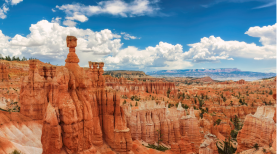
While often grouped with Zion, Bryce Canyon is geologically distinct. It is not technically a canyon but a collection of giant natural amphitheaters. The defining feature of Bryce is the hoodoo—tall, thin spires of rock that protrude from the bottom of the arid basins. These structures look like something from another planet, leading many to describe the park as an interstellar landscape.
The Science of Hoodoos
Hoodoos are formed by two primary processes: frost wedging and rainwater erosion. Bryce sits at a high elevation, meaning it experiences over 200 freeze-thaw cycles per year. Water seeps into cracks in the rock, freezes, expands, and breaks the rock apart. Over time, this creates the fins and eventually the isolated spires. The varying hardness of the rock layers causes the hoodoos to have irregular, whimsical shapes.
The Bryce Amphitheater
The most spectacular section of the park is the Bryce Amphitheater, which is filled with thousands of hoodoos. Trails like the Navajo Loop and Queen’s Garden allow visitors to descend into the heart of these formations. The contrast between the bright orange rock, the deep green of the Ponderosa pines, and the brilliant blue Utah sky creates a visual palette that is unmatched in the natural world.

Antelope Canyon: The Labyrinth of Light and Shadow
Located on Navajo land near Page, Arizona, Antelope Canyon is the world’s most famous slot canyon. It is divided into two sections: Upper Antelope Canyon (The Crack) and Lower Antelope Canyon (The Corkscrew). This canyon was formed primarily by flash flooding, which smoothed the Navajo Sandstone into flowing, wave-like shapes that mimic the movement of water.
The Photography of Light Beams
Antelope Canyon is a pilgrimage site for photographers. During the summer months, direct shafts of sunlight radiate down into the narrow openings of the Upper Canyon, creating “God beams” that illuminate the dust in the air and the vibrant oranges and purples of the walls. The Lower Canyon, while more difficult to navigate with its narrow passages and ladders, offers more intricate rock textures and a longer, more adventurous exploration.
Visitor Protocol: Because the canyon is on a Navajo Reservation, it can only be visited via guided tours. This ensures the protection of the delicate rock surfaces and the safety of visitors, as slot canyons are extremely susceptible to sudden, life-threatening flash floods even if it is not raining in the immediate vicinity.

Yarlung Zangbo: The Depths of the World
In the remote regions of Tibet lies the Yarlung Zangbo Grand Canyon, the deepest and longest canyon on the planet. It wraps around the majestic Namcha Barwa peak in a “Great Bend,” creating a landscape of extreme verticality. The canyon drops from the high-altitude Tibetan Plateau down to the lush jungles of the Indian border, representing one of the most significant biological corridors in the world.
Extreme Biodiversity and Geography
The canyon acts as a moisture channel, allowing the Indian Ocean monsoon to penetrate deep into the Tibetan Plateau. This creates a unique ecosystem where alpine glaciers exist just miles away from subtropical rainforests. The depth of the canyon reaches an incredible 6,009 meters (19,714 feet), making it significantly deeper than the Grand Canyon in the United States.
- The Great Bend: A U-shaped turn where the Yarlung Zangbo River flows around the Himalayas.
- Rare Species: The canyon is home to the Bengal tiger, the snow leopard, and numerous endemic plant species.
- Cultural Heart: For Tibetans, the canyon is a place of deep spiritual resonance, often associated with the concept of “Shangri-La.”

Tara Canyon: Europe’s Emerald Frontier
Often referred to as the “Tear of Europe,” the Tara River Canyon in Montenegro is the deepest canyon in Europe and the second deepest in the world after the Grand Canyon (though Yarlung Zangbo is now recognized as deeper). Part of the Durmitor National Park, a UNESCO World Heritage site, Tara Canyon is a lush, green contrast to the red rock canyons of North America.
The Wizard of Oz Landscape
The canyon is famous for its crystal-clear turquoise water and dense forests, giving it an ethereal, “Wizard of Oz” quality. The Tara River is one of the last wild rivers in Europe, making it a premier destination for white-water rafting. The Đurđevića Tara Bridge, once the largest concrete arch bridge in Europe, provides a breathtaking vantage point 172 meters above the river floor.
Conservation and the Black Mountain
The name Montenegro translates to “Black Mountain,” referring to the dark coniferous forests that cover the limestone peaks. The Tara Canyon is a vital sanctuary for European wildlife, including brown bears and wolves. Conservation efforts have been paramount here, successfully stopping dam projects that would have flooded this pristine ecosystem.

Fish River Canyon: Namibia’s Arid Whisper
Located in the south of Namibia, the Fish River Canyon is the largest canyon in Africa. It features a gigantic ravine, in total about 160 km (100 miles) long, up to 27 km wide and in places almost 550 meters deep. Unlike the lush Tara or the river-heavy Zion, Fish River is a place of stark, desert beauty and intense silence.
The Fish River Hiking Trail
The Fish River Canyon is home to one of the most challenging hikes in Southern Africa. The 85km trail takes 4 to 5 days to complete and is only open during the cooler winter months (May to September). There are no facilities along the way, and hikers must carry all their supplies, sleeping under the stars. The trail follows the sandy riverbed, which is often reduced to a series of isolated pools during the dry season.
Geological Origins
The canyon’s formation began about 500 million years ago. It was created not only by water erosion but also by the collapse of the valley bottom due to movements in the earth’s crust. The ancient metamorphic rocks exposed at the bottom of the canyon are some of the oldest in Namibia, dating back over a billion years.

Comparative Analysis of Global Canyon Systems
To better understand the diversity of these landscapes, we can compare them based on their primary characteristics and geographical context. Each canyon offers a different “personality,” from the accessible beauty of Zion to the extreme isolation of Yarlung Zangbo.
| Canyon Name | Location | Key Feature | Primary Rock Type |
|---|---|---|---|
| Zion Canyon | Utah, USA | The Narrows / Angels Landing | Navajo Sandstone |
| Bryce Canyon | Utah, USA | Hoodoos and Amphitheaters | Limestone / Siltstone |
| Antelope Canyon | Arizona, USA | Slot Labyrinth / Light Beams | Navajo Sandstone |
| Yarlung Zangbo | Tibet, China | World’s Deepest / Great Bend | Metamorphic / Igneous |
| Tara Canyon | Montenegro | Turquoise Water / Rafting | Limestone (Karst) |
| Fish River Canyon | Namibia | Arid Vastness / Multi-day Trek | Metamorphic / Sedimentary |

Frequently Asked Questions (FAQ)
- Q1: What is the best time of year to visit the canyons in the American Southwest?
- The ideal times are Spring (April to May) and Fall (September to October). During these periods, the temperatures are moderate, making strenuous hikes like Angels Landing or the Narrows much safer and more comfortable. Summer can see temperatures exceeding 100°F (38°C), while winter can bring snow and ice, particularly at the higher elevation of Bryce Canyon.
- Q2: How is Antelope Canyon different from a regular canyon?
- Antelope Canyon is a “slot canyon,” which is much deeper than it is wide. While a standard canyon might have a wide floor with a river, a slot canyon is a narrow crevice formed by water rushing through a small crack in the rock and expanding it over millennia. This creates the undulating, wave-like walls that slot canyons are famous for.
- Q3: Is the Yarlung Zangbo Grand Canyon accessible to tourists?
- Accessibility is very limited. Due to its remote location in Tibet and its proximity to sensitive border regions, special permits are required. Most tourists visit the “Great Bend” area via organized tours starting from Nyingchi. The inner depths of the canyon remain one of the least explored places on Earth.
- Q4: Why are the hoodoos in Bryce Canyon so colorful?
- The colors come from oxidized minerals. The reds, oranges, and pinks are caused by hematite (iron oxide), while the yellows are caused by limonite. The purples are often a result of manganese oxide. As the rock weathers away, new mineral layers are exposed, constantly changing the “face” of the hoodoos.
- Q5: Can you hike Fish River Canyon year-round?
- No. Due to extreme heat and the risk of dehydration, the Fish River Canyon hike is strictly closed during the summer months. It is only open from May 1st to September 15th. Even during the winter, hikers must undergo a medical check-up to ensure they are fit enough for the grueling 5-day journey.