Canyons are among the most dramatic and awe-inspiring features on Earth’s surface. These deep, steep-sided valleys, carved by the relentless power of water and time, tell a story of immense geological forces and environmental change. Understanding their formation requires a journey into the heart of geomorphology, exploring a dynamic interplay between rivers, rock, and crustal movement. This guide provides a detailed analysis of the evolutionary logic behind this “negative topography,” dissecting the mechanisms that transform flat plains into profound chasms over millions of years.
The creation of a canyon is not a single event but a protracted process involving multiple interconnected factors. While a river is the primary artist, the canvas it works on—the land itself—must be prepared by other forces. From the slow, inexorable rise of tectonic plates to the type of rock that dictates the canyon’s walls, every element plays a crucial role. We will explore these core concepts in depth, from the fundamental physics of erosion to the grand narrative of iconic landscapes like the Grand Canyon.
The Primary Engine of Canyon Formation: River Downcutting
At the heart of almost every canyon’s story is the process of fluvial erosion, specifically a mechanism known as river downcutting. This is the vertical erosion that deepens a river channel, carving downward into the bedrock. Unlike lateral erosion, which widens a river valley, downcutting is the primary force responsible for the immense depth of a canyon. This process is driven by several key factors working in concert.
Understanding Vertical Erosion vs. Lateral Erosion
A river’s energy can be directed in two ways: downwards or sideways. In areas with a steep gradient (a sharp downward slope), the river’s flow is fast and powerful, concentrating its erosive energy on the riverbed. This leads to aggressive vertical incision, or downcutting. In contrast, on flatter plains, the river slows down, meanders, and its energy is directed towards eroding its banks, leading to lateral erosion and the formation of wide, open valleys. For a canyon to form, conditions must heavily favor downcutting over lateral erosion for a prolonged geological period.
The Role of Sediment Load: A River’s Liquid Sandpaper
Water alone is a surprisingly inefficient agent for eroding solid rock. The real work is done by the sediment load the river carries. Rocks, pebbles, sand, and silt suspended in the water or dragged along the riverbed act as abrasive tools. This process, known as abrasion, is akin to liquid sandpaper grinding away at the bedrock. The harder and more angular the sediment particles, and the greater their volume, the more effective the river is at carving its channel deeper. The constant scraping and collision of these particles wear down the riverbed, bit by bit, over millennia.
The Influence of Water Velocity and Gradient
The speed and volume of water flow are critical. A river’s velocity is largely determined by its gradient. A steeper slope, often created by tectonic uplift, causes water to accelerate due to gravity. This increased velocity not only enhances the abrasive power of the sediment but also allows the river to carry larger, more destructive particles. During flood events, when both water volume and velocity surge, the rate of downcutting can increase exponentially, performing more erosive work in a few days than in years of normal flow.

Tectonic Uplift: Setting the Stage for Deep Incision
A river cannot carve a deep canyon if the land is at or near sea level. The crucial prerequisite for significant downcutting is tectonic uplift—the large-scale vertical movement of the Earth’s crust. This process raises a landmass, often a plateau, thousands of feet into the air. It is this elevation gain that provides the river with the potential energy it needs to perform its erosive surgery on the landscape.
How Uplift Increases a River’s Erosive Power
As the land rises, the river’s gradient steepens dramatically. Imagine a river flowing across a flat plain that is slowly being lifted. The river’s starting point is now much higher than its end point (the sea), forcing it to flow faster and more aggressively to reach its base level. This rejuvenation of the river system transforms it from a meandering, depositional stream into a high-energy, erosional powerhouse. The uplift essentially “sets the table,” giving the river the elevation difference required to carve deeply into the rising landmass instead of being diverted or simply widening its valley.
Case Study: The Colorado Plateau and the Grand Canyon
The Grand Canyon is the quintessential example of this principle. The formation of the canyon was not possible until the entire region, known as the Colorado Plateau, was uplifted thousands of feet. This process, which occurred over the last several million years, gave the ancestral Colorado River an incredibly steep gradient. As the plateau rose, the river was forced to cut down through the accumulating rock layers, maintaining its course and incising deeper and deeper. Without the massive, broad uplift of the Colorado Plateau, the Colorado River would never have had the power to carve the mile-deep chasm we see today.

The Geological Canvas: How Rock Types Dictate Canyon Shape
The final form of a canyon—its width, the steepness of its walls, and its characteristic features—is heavily influenced by the geology of the rock it cuts through. Not all rocks are created equal; some are highly resistant to erosion, while others are soft and easily worn away. This variation, known as differential erosion, is responsible for the intricate and layered appearance of many canyons.
Hard vs. Soft Rock Layers: Creating Steps and Cliffs
When a river cuts through alternating layers of hard and soft rock, a distinct “stepped” profile emerges.
- Hard Rock Layers: Resistant rocks like granite, sandstone, and limestone do not erode easily. They form sheer, vertical cliffs because they can maintain a steep face without crumbling.
- Soft Rock Layers: Softer rocks like shale and mudstone are quickly weathered and eroded by water and ice. These layers tend to crumble and form gentler, sloping sections between the hard rock cliffs.
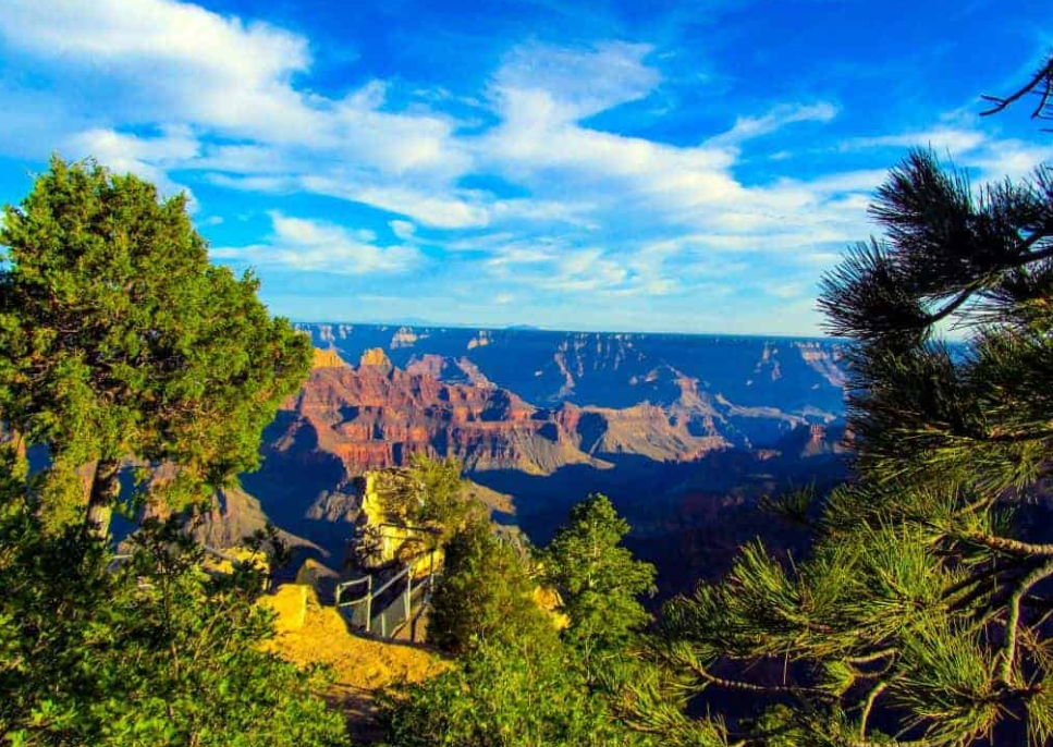
This interplay creates the classic canyon profile of a series of vertical cliffs separated by sloped terraces, a pattern clearly visible in the Grand Canyon’s walls, where layers of Coconino Sandstone form prominent cliffs while the Hermit Shale forms gradual slopes beneath them.
Differential Erosion and the Formation of Mesas and Buttes
Over time, as the main canyon deepens, tributary streams begin to carve side canyons. The process of differential erosion continues on this smaller scale. Eventually, sections of the plateau can become isolated from the main landmass, protected by a cap of hard, resistant rock. These isolated, flat-topped landforms are known as mesas (if they are wider than they are tall) and buttes (if they are taller than they are wide). They stand as solitary monuments to the original height of the plateau before erosion stripped away the surrounding softer rock.

Amplifying Forces: The Role of Climate, Gravity, and Ice
While the river is the primary sculptor, other forces work to widen the canyon and shape its walls. These processes are often dictated by the regional climate and the constant pull of gravity. They are responsible for transforming a narrow, V-shaped gorge into the vast, open canyon systems we often see.
Weathering and Mass Wasting: Widening the Canyon
The canyon walls are under continuous attack from the elements. This process, known as weathering, breaks down the rock.
- Frost Wedging: In colder climates, water seeps into cracks in the rock, freezes, expands, and pries the rock apart.
- Root Wedging: Plant roots can grow into fractures, exerting pressure that widens the cracks.
- Chemical Weathering: Rainwater, which is naturally slightly acidic, can slowly dissolve certain types of rock like limestone.
Once the rock is weakened, gravity takes over in a process called mass wasting. This includes rockfalls, landslides, and debris flows, where large amounts of material collapse from the canyon walls and fall to the river below. The river then transports this debris downstream, effectively clearing the way for further downcutting and widening the canyon over time.
The Impact of Glacial Meltwater and Ancient Climates
Past climatic conditions have played a significant role in carving many of the world’s canyons. During ice ages, the melting of massive glaciers released enormous volumes of water. These cataclysmic meltwater floods possessed erosive power far beyond that of a normal river. They could scour out deep channels and transport massive boulders, rapidly accelerating canyon formation. Evidence from many canyons shows features that could only have been formed by flows of a magnitude not seen in the modern era, pointing to the profound impact of ancient climates.

When Canyons Choke: The Formation of Canyon Lakes
The life of a canyon is not always one of uninterrupted erosion. Sometimes, the river’s path can be obstructed, leading to the formation of a temporary or long-lived lake within the canyon itself. This phenomenon occurs when a natural dam blocks the flow of the river, causing water to back up and flood the upstream portion of the canyon.
Mechanisms of Obstruction: Landslides, Lava Flows, and Alluvial Fans
Several natural events can create a dam within a canyon. The most common is a massive landslide, where an entire section of a canyon wall collapses and chokes the river channel. In volcanic regions, lava flows can pour into a canyon, solidifying into a hard, durable dam of basalt. A third mechanism is the growth of an alluvial fan from a tributary canyon. If the side canyon deposits sediment and debris into the main channel faster than the main river can carry it away, it can build up a dam that obstructs the flow.
The Life Cycle of a Canyon Lake
Once formed, a canyon lake is a temporary geological feature. The lake will exist as long as the dam holds back the water. However, two processes are constantly working to eliminate it. First, the inflowing river deposits its sediment load into the still water of the lake, slowly filling it from the upstream end. Second, the water spilling over the top of the dam (or seeping through it) will begin to erode the dam itself. Eventually, the dam will either be completely eroded away or will fail catastrophically in a massive breakout flood, draining the lake and allowing the river to resume its course and its work of downcutting.

The Grand Canyon: A 6-Million-Year Geological Saga
The Grand Canyon stands as the world’s most famous testament to the power of canyon formation. Its creation is a complex story that geologists have been piecing together for over a century. While the rocks exposed in its walls are billions of years old, the canyon itself is a relatively recent feature, carved primarily within the last 5 to 6 million years.
The Unraveling of a Geological Mystery
For a long time, the age and formation of the Grand Canyon were hotly debated. The modern consensus is that it was not carved by a single, ancient river but was likely formed by the integration of several different river systems. One theory suggests that an ancient river flowing west was “captured” by a river system eroding eastward from the Gulf of California. This integration, combined with the continued uplift of the Colorado Plateau, created the single, powerful Colorado River that rapidly incised the canyon to its present depth.
Key Milestones in the Grand Canyon’s Formation
The creation of the Grand Canyon can be viewed as a multi-stage process involving a perfect storm of geological conditions:
- Deposition: For hundreds of millions of years, the region was covered by ancient seas, leading to the deposition of the horizontal layers of sedimentary rock we see today.
- Uplift: Starting around 70 million years ago, the Laramide Orogeny began to lift the Colorado Plateau. This was a slow, broad uplift that raised the entire region thousands of feet without significantly deforming the rock layers.
- Incision: Around 6 million years ago, the modern Colorado River system became established. Fueled by the high elevation and steep gradient provided by the uplift, it began its relentless process of downcutting through the layers of the plateau.
- Widening: As the river cut deeper, the forces of weathering, mass wasting, and erosion from tributary streams worked to widen the canyon, sculpting the cliffs, terraces, buttes, and mesas that define its iconic landscape.
This 6-million-year “crustal surgery” showcases the perfect alignment of river power, tectonic uplift, and differential erosion required to create a landform of such monumental scale.
Frequently Asked Questions (FAQ)
- How long does it take to form a canyon?
- The formation of a significant canyon is a process that takes millions of years. The rate of erosion is incredibly slow, often measured in just fractions of an inch per century. The precise timeline depends on factors like the rate of tectonic uplift, the hardness of the rock, the size of the river, and the climate. The Grand Canyon, for example, was carved over a period of 5 to 6 million years.
- What is the difference between a canyon and a gorge?
- The terms are often used interchangeably, but geologists sometimes make a subtle distinction. A canyon is typically a large-scale feature, often with a wider, more open profile due to significant weathering and mass wasting on its walls. A gorge is usually a smaller, narrower, and steeper-sided feature, often indicating that it was carved through very hard, resistant rock that prevents the walls from collapsing and widening.
- Can canyons form without rivers?
- While the vast majority of canyons are formed by river erosion (fluvial canyons), other processes can create similar features. Submarine canyons are carved on the ocean floor by turbidity currents, which are underwater avalanches of sediment-laden water. On a smaller scale, some canyons can be formed by tectonic activity, creating a rift or fault-line valley. However, the classic, grand-scale canyons seen on continents are almost exclusively the work of rivers.
- What is the deepest canyon in the world?
- The deepest canyon in the world is the Yarlung Tsangpo Grand Canyon in Tibet, China. The Yarlung Tsangpo River carves through the Himalayas, creating a canyon with an average depth of over 7,440 feet (2,268 meters) and a maximum depth of 19,714 feet (6,009 meters). It is significantly deeper than the Grand Canyon in the United States, which has a maximum depth of about 6,000 feet (1,829 meters).
- How does human activity affect canyons?
- Human activity can significantly impact canyons, primarily through the construction of dams. Damming a river drastically alters its behavior. Upstream, the river drops its sediment in the reservoir, preventing it from reaching downstream areas. Downstream, the river flows with clear water (“hungry water”) which can have increased erosive power on the riverbed and banks immediately below the dam. This starves beaches and sandbars of new sediment and can fundamentally change the canyon’s ecosystem and geomorphology.